Here are some personal stories of knowing when to say ‘no’ to risking that little bit of bad weather.
We’ve all been there. The plans have been in place for weeks, and people are relying on you to be at a certain place at a certain time.
The weather on the day is looking a bit rough, but an experienced pilot can easily navigate that, because the most important thing is to get there on time…right?
Sadly, this approach to toughing out inclement weather often results in CAA safety investigators seeing similar accident scenes time and time again.
It’s what sends them to your family, with the difficult job of trying to explain what happened in the air that day.
CAA Safety Investigator Lou Child points out that a common theme to these accidents is a lack of preflight weather planning for the entire route.
“When they encounter deteriorating weather, some pilots seemed determined to push on, often well below VFR MET minima. When the flight also continues below VFR minimum safe heights, things really start to stack up against them.
“Flying below VFR minimum heights in reduced visibility means the pilot has less time and fewer options to turn around or avoid terrain and obstacles.”
However, things don’t have to work out that way. With some thorough flight planning, and a little bit of flexibility to adapt your plans when needed, you can get to where you need to be – alive and well.
Here are some personal stories from New Zealand aviators about when weather woes have disrupted their well-laid plans, and how they responded to keep themselves and others safe.
Mark Woodhouse - Waypoints Aviation
 Mark is the joint owner of Waypoints Aviation. He’s an experienced ATPL ground instructor, and an Air New Zealand pilot recently retired from flying the Boeing 787-9 Dreamliner.
Here, Mark reflects on a situation when someone he was coaching chose to be flexible and adapt to the weather conditions, rather than push the boundaries of safety.
“Some time ago, I was gearing up to carry out a flight test for a PPL candidate. They had only a narrow window of time to complete the test, because they were soon heading out of town for an extended period.
“We’d scheduled a time for the test, but when the day came, the weather wasn’t ideal. In fact, I’d say it would’ve been entirely unsuitable.
“I didn’t want to pressure the candidate, or prompt a decision from them, so I sat on my hands and waited to hear from them. To the candidate’s credit, they contacted me and asked if we could delay the test.
“Interestingly, the candidate confessed they’d been worried that we (myself and their instructor) would think less of them for delaying the test. Of course, I supported the decision they’d come to of their own volition.
“What I didn’t tell them was that if the test had gone ahead in the inclement weather, I was almost certain that it wouldn’t have been successful.”
Mark admits that making ‘no go’ or ‘turn back’ decisions can be difficult when a pilot first starts out, but feels this does become easier with practice.
“I’ve always felt that flying instructors would do well to take their students out in marginal conditions, to demonstrate the true application of such decision-making.”
Paul Holland - Kāpiti Districts Aero Club
 Paul is a former flying student with Kāpiti Districts Aero Club. Here, he describes a dual crosscountry training session in a Piper Tomahawk PA-38 with instructor Diego Acevedo, where the weather unexpectedly deteriorated and forced some quick thinking and a change in plans.
“After preflight and ground planning, we departed Paraparaumu en route to Palmerston North, Whanganui, and then back to Paraparaumu.
“The weather was overcast at 3000 feet, with the forecast indicating the cloud should be lifting and clearing.
“We made it to Palmerston North at 1500ft with no problem, just a slight deviation to skirt around a little bit of lower cloud.
“We stopped there briefly, dipped the tanks to confirm fuel burn, and re-checked the weather – which still indicated the cloud should be lifting.
“Palmerston North to Whanganui was uneventful, and the sun was out when we landed. We stopped briefly at Whanganui, before flying south along the coast back to Paraparaumu.
“After about 10 minutes, the cloud ahead was looking a lot lower than what was forecast. We continued south, but the cloud ceiling was coming down, the further we went, forcing us to descend.
“It appeared as if the cloud was down to sea level, although it was hard to determine.
“Throughout this time, Diego was talking to me about the conditions, and asking my opinion on the best course of action.
“At around 1000ft, with the cloud in front looking like it was impassable, I told Diego I would like to turn back toward Whanganui to wait it out, and see if the cloud lifted.
“Diego agreed, and we turned back. We also had radio comms with another Kāpiti aircraft which was tracking north on the other side of the same cloud bank, and had also turned back.
“Once on track back to Whanganui, we discussed our options and decided we would track back along our original route past Palmerston North, and home to Paraparaumu.
“We called air traffic services, advised them of the change to our flight plan, and tracked toward Fordell, then the VRP of Marton Reservoir, and on to Palmerston North.
“As we approached Feilding, we were again forced by low cloud to descend, and started to get into some light showers. We continued at approximately 1000ft, and deviated to head between some areas of rain.
“About five minutes past Feilding, it became apparent that the same low cloud stopping us heading down the coast was now inland. Forward visibility was reducing, and we agreed we were unlikely to be able to get home. So, we turned back and landed at Feilding.
“We parked up, got a ride into the Feilding town centre, and went to a cafe to get some lunch. We rang the aero club at Kāpiti to let them know where we were, and they mentioned the cloud had come right down there, so we wouldn’t have been able to land VFR even if we had made it back.
“One of the other instructors offered to fly IFR to pick us up from Palmerston North, so we headed back to the Feilding airfield to make our way to Palmerston North.
“The cloud base was low, but we only needed to get up to 1500ft to fly the VFR approach into Palmerston North. From the ground it looked like we would be able to get up to that altitude, so we took off.
“As we climbed out on the crosswind leg, we started to get close to cloud at approximately 600ft. We immediately stopped climbing, completed a low circuit, and landed again at Feilding.
“From 600ft, we couldn’t even see Palmerston North – which is only about 4NM away.
“We went back to the Feilding town centre and someone from the club ended up driving 90 minutes to pick us up. The plane was recovered a couple of days later.
“I’m grateful I was with an instructor during my first weather diversion. Diego allowed me to fly and make decisions, but it was good for me to discuss what I was seeing, and have his experience to learn from.
“For me, the lesson from this was that forecasts aren’t always accurate. According to MetFlight, the cloud should have been clearing, not getting worse, so constant situational awareness in the aircraft is vital.”
Ross Millichamp - AOPA NZ
 Ross is the vice-president of the Aircraft Owners and Pilots Association New Zealand. Here, he shares an experience where he made a wise decision to stay safe in deteriorating weather conditions.
“Private aircraft operators encounter more than their fair share of weather issues. We often travel far from home and for extended periods of time, with little confidence about the likely weather on the return journey.
“We also have no aero club supervision or office safety management system support. In short, we tend to be on our own up there.
“I regularly travel to the North Island from our home base near Darfield, and find the Cook Strait area to be where I encounter most weather problems.
“On a recent trip to Whanganui, the pre-departure weather reports suggested good conditions most of the way, with the lowest cloud base – 1200 feet – predicted to be around the Kāpiti coast.
“Once airborne, I checked conditions at Wellington and Paraparaumu using MetFlight.
“Overhead Kekerengu, I called Wellington Approach to request radar monitoring across the Strait, and for a more personal assessment of the weather on the far side.
“They reported that Wellington was fine and clear, and offered to call the Paraparaumu Flight Information Service for an up-to-date report there. Wellington Approach got back to me a short time later to report the cloud base at Paraparaumu was now down to 1000 feet.
“Midway across the Strait, Wellington Approach called again to advise the cloud had lowered to 800 feet at Paraparaumu, and asked what my intentions were.
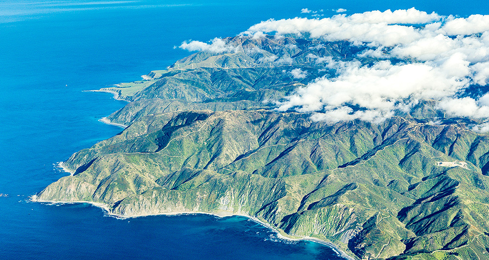
“The problem with tracking close to the south Wellington coast in northerly conditions is that it’s bumpy.” – Ross Millichamp | Photo: Rob Suisted/naturespic.com
“One aspect of crossing the Strait from Cape Campbell to Ōhau Point is that you can’t see the weather on the Kāpiti coast until you’re almost there.
“I advised that I’d take a look around the corner and report back. As I approached Ōhau Point, Wellington Approach once again interrupted their calls to airline traffic to ask if I ‘could see the North Island?’ I was getting the idea that they were a little worried.
“The reality of the situation was that both Wellington Approach and I knew what the weather was doing in Wellington and at Paraparaumu, but had no idea of what lay between.
“I advised that I could, indeed, see the North Island, and was close to being able to see up the west coast. As I came around Ōhau Point, I was confronted with the sight of cloud down to sea level and no prospect of continuing to Whanganui.
“I’d been tracking slightly out to sea, and had the space to make a reverse turn with land in sight at all times. Once I was heading back south, I called Wellington Approach and advised that I’d abandoned my attempt to reach Whanganui and would track along the coast towards Wellington while I decided what to do next.
“The weather over the Strait had started to deteriorate as a northerly front pushed through, and although it would probably be possible to reach Marlborough, I was running out of enthusiasm for grovelling around over the water in deteriorating weather.
“On any long-distance flight, I usually print out the AIP charts for airfields that I might need to divert to.
“This time, one airfield I’d neglected to consider was Wellington. It has the reputation of being busy, and in my experience, it almost always has the worst weather in the area. I looked down at the hefty AIP Vol 4 on the floor of the aircraft, and considered trying to find the VFR arrival procedures among the 20-odd pages dedicated to operating in and out of Wellington.
“The problem with tracking close to the south Wellington coast in northerly conditions is that it’s bumpy. Trying to find the right page in the AIP, or trying to access it on a touchscreen tablet in rough conditions, with no passengers to help, would have been an exercise in futility.
“Instead, I threw myself on the mercy of Wellington Approach and asked 'Can you talk me through an arrival into Wellington? I have no idea what the arrival procedures are, and don’t fancy trying to find them in the AIP in these conditions.'
“Ten minutes later, I was clearing the taxiway onto the western apron at Wellington Airport, and called the tower to thank them for their assistance.
“I was expecting, however, to hear the dreaded words ‘Juliet Bravo Tango, please call the tower on completion’, a sure sign that I’d done something wrong.
“Instead, they graciously acknowledged my thanks, and simply suggested that I talk to an instructor at the Wellington Aero Club for a departure briefing before my next flight.”
Aviate – navigate – communicate
Ross says at the end of the day, don’t let the weather get the best of you.
“Looking back on the day, I realise that no matter how well you prepare for a flight, and no matter how much technology you have available in the cockpit, New Zealand’s changeable weather will always hold the trump card.
“And when the weather does turn against you, follow the old adage of aviate first, then navigate, and finally communicate.
“And if everything goes wrong, ask for help!”
For more information
Accident reports
You can read accident reports that illustrate the theme of this article by going to:
Relevant reports include:
Vector articles
The following past Vector articles provide more information on this topic.
Autumn 2022: The value of preparedness
Spring 2020: Flight planning – not a quick once-over
Summer 2019/20: What is your life worth?
May/June 2017: So you don’t think you need a NOTAM?
Good Aviation Practice (GAP) booklets
The following GAP booklets provide more information on this topic.